Improvement of Cypress Bayou Approved June 10, 1872, March 3, 1873 |
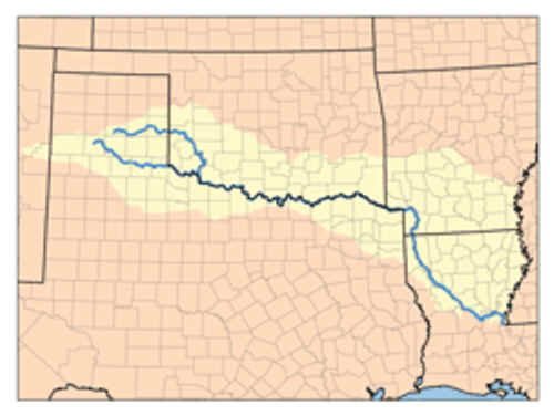
Red River (Mississippi watershed
Improvement of Cypress Bayou Approved June 10, 1872, March 3, 1873 Part One
CONSTRUCTION OF DAM-MATERIAL.
The neighboring country affords an abundance of cypress timber, which may be delivered in rafts at the site of the work during high- water. Albany Bluff affords a good clayey soil. Albany and the neighboring bluffs will furnish, it is thought, enough stone (of a quality not suitable for masonry) that will answer for ballast. No other material for construction can be had except from a great distance and at great expense.
The dam must therefore be mainly built of timber.
A pile-dam, judging from the fate of that built across Tone's Bayou, would probably not stand long.
A framed dam would be difficult of construction, costly, and offer no better hope of permanency than one made by piling.
In the Red River raft we found numerous large islands, (comparatively speaking,) formed by an accumulation of timber, cemented together by river-deposit and the roots of willows ; these were able to withstand the full force of the river-current during the floods and were difficult of removal by machinery, even when aided by nitroglycerine.
It is proposed to imitate this natural formation, as is best shown by the drawings herewith, by building a dam with untrimmed cypress-trees, placed butts down-stream, layer over layer, with the interstices filled in with earth from the bluff', and the top and apron ballasted with stone.
On this plan the cost of a tumbling-dam, No. 1, is estimated at $57,661, viz:
4,437 trees, (in place.) at $4 $17,736
1,576 cubic yards earth, (in (lain,) at 50 cents 788
10,120 cubic yards ballast, (in dam,) at $3...' 30,300
Add '20 per cent, contingencies 9,777
Total 57,661
The cost of dam No. 3 is estimated at $217,314, viz :
24.S96 trees, (in place,) at .$4 $99,584
75,950 cubic yard earth, (in dam.) at 50 cents 37,975
20,000 cubic yards ballast, (in dam,) at $3 60,000
Add 10 per rent, contingencies 19,755
Total 217,314
Note.—Only 10 per cent, is added in this case because of the magnitude of the work and its offering no more uuder-water work than No. 1 does.
THE CUT.
The place of the cut is indicated on Leavitt's chart. The estimated excavation for it is—
467,170 cubic yards, which, at 30 cents per cubic yard, will make it cost $140,151
Add 10 percent, for contingencies. 14,015
Total 154,166
Total cost of dam No. 1 and cut 211,827
Total cost of dam No. 3 and cut 372, 580
The estimate for the dam is based on the assumption that all material for it is to be collected, so that the dam may be constructed during a single low-water season.
The estimate for the cut is based on a width of 60 feet at top, 30 feet at bottom, and я uniform depth of 6 feet below low-water mark.
It is thought that perhaps a cut of lesser dimensions may answer, on the supposition that the currents through it may scour it wider and deeper. This consideration, however, could not be made to safely enter the estimate.
The following report of Mr. Leavitt contains such commercial statistics as I have been able to collect :
Report of Mr. H. A. Leavitt, Assistant Engineer.
New Orleans, May 28,1874.
Captain: I have the honor to submit the following report of survey of that of Cypress Bayou known as Soda Lake and Twelve-mile Bayou :
The field of operations extend from Albany Flats, four miles from the foot of Lake, to Shreveport, La., a distance of some seventeen mile.
The field-work was commenced January 5, 1874, and completed March l0, 1874 having occupied a little over two months.
Before completing the organization of my party, I spent two days in making a preliminary examination. Owing to the high stage of the water, and the probability- a still further rise, I concluded, to begin my work at Albany Point, with a view to ascertaining the cost of a lock and dam located at that point, as recommended Lieutenant Woodruff, assuming that to be the only way in which the difficult.« Albany Flats could be overcome.
On January 10, having perfected my organization. I went into camp at Albany Point and established gauge, taking readings morning and evening until the close of the survey.
My progress was very much hindered by the dense growth of timber which line both shores of the lake and islands, and much time was lost in clearing sights. Had the survey been made during low-water much more work could have been done and will better results.
The field-work of Soda Lake was made from a base-line located one-half mile above Albany Point and, where opportunities offered, tie-lines were measured as checks on tV work.
For the line down Twelve-mile Bayou the stadia was used.
Accompanying this report are—716
1st. One general map, showing the country in the field of operations, with sections of Albany Point, Cross Lake, and Twelve-mile Bayou, also section through channel from the flats to Shreveport, with water-slope of January 20, l!-74.
2d. Detailed drawings of proposed dam, showing front elevation, plan, and sections
The soundings are reduced to gauge-readings of January 20, that being the date of the lowest stage during time of survey. The highest water-mark of 1866 was obtained from Mr. Howe, who has lived at Albany Point for some twenty years. The mark shown me was a stake driven in the ground near a stump which protected it from anything that would be likely to disturb it. I compared it with well-defined marks found at the timber at the head of Blind Bayou and found them to agree very closely. Tb» extreme low-water mark on Albany Flats is not so reliable. I was obliged to depend ч the statements of parties of whom I made inquiries. I was informed that daring low- water " one could wade anywhere on the flats without getting their feet wet, and that navigation even by skiffs was a matter of difficulty.
With the above uncertain information I assumed one foot on the flat« to W very ; extreme low water.
I obtained from the Signal-Service office at Shreveport the record of the gauge for the time during the survey, and from the files in this office the high and low for 1873.
The section shown by dotted red line on map through channel from Albany Flat to Shreveport was fixed by triangulation from base and shore line, after careful soundings at right angles; across the channel signal-flags were put up in the deepest waters found.
This channel is used by all boats, when there are 6 feet and less on the flats, at 6 feet and over, what is known as the "Cut Road," and indicated on the map by dotted black lines, from Albany Point to the ' Gate Post," is used ; it is of little benefit, however for navigation, as the saving in distance over the crooked channel of the bayou compensate for the risk run in "picking up stumps."
The Cut Road, as the term indicates, consists in chopping the standing timber during low-water, and is resorted to very often in the lake-navigation to save distance during high-water.
The fall, as shown by water-slope, is 11.82 feet when there is 6 feet' of water on the flats ; at extreme low-water it is 18.24 feet, and for high-water of 1873 it is 8.85.
The section shown in blue, and marked Leavenworth's section, is submitted to show the difference of level between Soda Lake and Red River, October 20, 1867, and high- water of 1866.
After completing survey in vicinity of Albany Point, I located a line shown in red, and by section С, D, for the purpose of making estimates of proposed lock and dam. Borings were taken to a depth of 34 feet, and specimens preserved wherever a change of material was found.
Sections of borings are shown, and the materials and depths found marked.
The following table of difference of level between Albany Point and Shreveport is submitted to show that should a lock and dam be constructed at Albany Point, another would be required located near the mouth of Twelve-mile Bayou to hold navigation good to that point.
The zero of the United States gauge at Shreveport is taken as the plane of reference-
| >> | ¿ | э | fr | É | |||
| J | g | S | £ | О | |||
| Date. | ^i | »t | §3 | Date. | «1 | &t | s? |
| fl | äÄ | P | ¿à | tu | £Д | ||
| 1874. | О | в | 5 | 1874. | ê | cr | 5 |
| 87.64 | 16 82 | 10.82 | 29 46 | 19 93 | 9 S3 | ||
| 16 | °7 49 | 16 6*> | 10 Н4 | 29 81 | 20 42 | <i зч | |
| 17 | 27 26 | 16 32 | 10 96 | 19 | 29 97 | 20 67 | 9 30 |
| 18 | 27 14 | 16 07 | 11 07 | 11 | 30 09 | 20 93 | 9 16 |
| 19 | 88 96 | 15 73 | il 23 | 13 | 30.17 | 21 17 | 9 00 |
| 81 | 2«. C9 | 15.07 | 11.82 | 13 | 30.59 | 21.50 | 9 09 |
| 84 | 26. 94 | 15. 00 | 11.94 | 14 | 30. 70 | 22.00 | 8.70 |
| 85 | 26 90 | 14 67 | 12.33 | 15 | 30 83 | 22 33 | 8 50 |
| 26 . . | 2li 94 | 15 07 | 11 87 | If, | 30 &3 | 22. Г* | 8 25 |
| 31 | 27.39 | 16. 17 | 11 82 | % | 30.84 | 22.33 | 8.51 |
| February 1 | 27. 57 | 16.73 | 10. 84 | 32. 14 | 23.58 | 8.56 | |
| 3 | 2H 00 | 17 4н | 10 52 | Hißb- water 1873 | 36 34 | 27 49 | 8 85 |
| 6 | 28.91 | IS. 90 | 10.01 | Low-water, 1673 | SI. 89 | 3.65 | 18.24 |
As the plan assumed to overcome the difficulties of Albany Flats by lock and dam, from the nature of the foundations, scarcity of material for ballast, and the necessity of a similar structure in Twelve-mile Bayou was thought too expensive, and the construction attended with many difficulties, I was led to examine some other method more safe and reliable.
I extended my survey down Cross Lake to a point offering very favorable advantages for the construction of a dam. The width of Cross Lake at this point is 1,025 feet, and completely filled with cypress stumps from 2 to 4 feet in diameter and standing some 6 feet above ordinary stage of the lake, presenting a firm anchorage. The west shore of the lake is very abrupt, with an elevation of 40 feet above the water. Sections of Cross Lake and Twelve-mile Bayou are shown, and marked E, F, A, B.
The plan proposed would be a high-water dam, crest of dam 2 feet above highest known water, located on line E, F, A, B, and extending 1,000 feet from B. Total length of structure, 2,000 feet; and a channel cut from Twelve-mile Bayou to Red River on line L, N, section shown. Length of cut, 1,100 feet.
The construction of the dam is shown by the detail-drawings, and consists of trees and earth, the west shore of the lake furnishing both materials in abundance. The trees would be taken just as they fall from the stumps and placed in position, the tops upstream and butts resting on timbers placed parallel with line of dam. After placing one layer in position as closely as possible, the spaces are filled with clay, well rammed. This is repeated until the desired elevation is obtained. The front slope is 2 to 1, and rear 1 to 1.
The distance from Twelve-mile Bayou to Red River, measured on line of dam, is 4.500 feet. As the proposed structure would occupy 1,000 feet, this would give 3,500* feet for high-water-way.
The banks of Red River are 6 feet higher than Twelve-mile Bayou. This would give an area of some 18,000 square feet before Red River would be called upon to assist in carrying flood.
The object in leaving this water-way is to afford protection, during a flood, to the structure, by allowing the water to escape and back up in the rear of the dam and form a cushion to receive the overflow and prevent undermining.
During high-water the whole country is submerged, and there is but little current. This, together with the tact that the proposed outlet is heavily timbered with oak, gum, cypress, &c., indicates that no danger may be apprehended that a new channel would be formed between the end of the dam and Red River.
The difference of level between Twelve-mile Bayou and Red River, on section L, N, March 6, 1874, was 0.07 of a foot, and the fall from site of dam to mouth of Twelve- mile Bayou, March 7, 1874, was 3.06 feet.
The distance by Red River from proposed cut to mouth of Twelve-mile Bayou is 9.66 miles, while from dam to same point is but 3.64 miles. This would lengthen the water- slope over two and one-half times what it now is, with the same fall. The elevation of the banks of Twelve-mile Bayou is 30.90, and when bank-full would give 10 feet on the flats. As the dam would cut off the escape of water by Cross Lake and Twelve- mile Bayou, the only outlet during a good boating-stage would be by Red River, and we would then have all of the lakes as a reservoir for slack-water navigation.
The estimates on this plan were not completed, as, by your directions, the location was changed to Albany Point.
The site on which estimates were made is a line running from Albany Point to Gold Point, on Red River, taking advantage of Islands Nos. 1 and 2.
The crest of the dam is, at an elevation of 42.98 feet, (above zero of gauge at Shreveport,) 2 feet above high-water of l*(>u at Albany Point. This elevation is carried 1,000 feet inland from north shore of Soda Lake, at which point it falls 0.53 per 100 feet fur a distance of 1,500 feet, when it reaches an elevation of 34.9H, at which it is carried a distance of 3,100 feet, where it reaches the slopes of Red River bank. Total length of dam, 10,400.
The proposed cut is shown by red line from Blind Bayou to Red River. For a portion of the way Blind Bayou would be used; very little improvement would be needed, and would consist in dredging and removing stumps.
The main cut would be through red clay and sand, and is susceptible of easy handling.
The benefits to be derived from this plan ore as shown by Leavenworth's section: Red River is 3.80 feet above Soda Lake ; the elevation of the low portion of the dam is 34.IW; this would give 14 feet on the flats before allowing any water to escape.
The fall from Jefferson to Albany Point, as stated in Lieutenant Woodruffs report, is but 3.50 feet ; this would give over 10 feet of water to Jefferson.
The distance by Red River, from Gold Point, to mouth of Twelve-mile Bayou, is nearly twice a« great as by Soda Lake and Twelve-mile Bayou. This increased distance with difference of level will no doubt materially lengthen the boating-season, and, in my opinion, secure navigation to Jefferson when Red River is navigable to Shreveport.
The following statistics were kindly prepared by Messrs. Johnson & Eberstadt, of Jefferson, Texas, and to whom I am indebted for much valuable information.
While in Jefferson I paid a visit to Kelly's foundry and iron-works, and examined the ore and castings made from it, and can safely vouch for the statements made by Mr. Kelly.
I remain, very respectfully, your obedient servant,
H. A. LEavItt, . Е.Leavitt
Capt. C. W. Howell.,
Corps of Engineer», U. S. A.
COMMERCIAL STATISTICS.
We ask, in behalf of the citizens of Jefferson and adjacent county, to lay before you the following facts and statistics, showing the importance of Government aid for the benefit of navigation through the bayou and chain of lakes between the cities of Jefferson, Texas, and Shreveport, La., a distance of ninety-live miles.
For several years, just after the close of the war, there were shipped annually t h mush this channel to New Orleans from sixty to seventy-five thousand bales of cotton, at a freight-cost of from $1 to $2.50 per bale; besides large numbers of beef-cattle, large quantities of hides and other productions, and articles of commerce.
In 1869 the number of bales of cotton reached 75,352; hides, 160,000; and all other classes of products in like ratio. During the same commercial year the number of packages of merchandise landed here for the interior reached over 350,000. valued at $1,750,000, while the value of merchandise received by the merchants of Jefferson was $20,000,000. At that time the population of the city was 11,000 souls, and business of every class was prosperous in the extreme.
Since that time, from various causes, trade and commerce have been gradually diminishing, and principal among these causes has been the lessening of our navigation. arising from the expenditure of Government appropriations on the Upper Red River in and about the great raft.
We may here also beg leave to say, and call attention to the fact, that the cutting out of this raft and the turning loose of so great a volume of water, is proving very detrimental to farming-interests on Red River below Shreveport ; while, we are assured by our oldest and most competent steamboat-men that but little, if any, good will result from the work to the upper-river navigation.
Whether this he fact or not we are not positively prepared to declare ; but, if so, we hope that some clause may be found in the Constitution that prevents the interference of the General Government in benefiting one section of the country and people at the expense and ruin of another.
But should Congress grant the appropriation of $300,000 now asked for, for the permanent improvement of the lake-navigation in either of the feasible ways that have been suggested by engineers, it will settle all existing difficulties, and benefit a larger population and more territory than any appropriation of the same amount ever made by Congress.
To prove this statement we offer the following facts, together with the agricultural statistics of the territory immediately surrounding and entirely dependent on this outlet for its exports and imports, leaving out many counties even more populous and with larger productions than most of those named. These statistics, too, are from the census of 1870, the latest at command, since which time the population and products have increased 40 per cent.
| « | Cotton-baleH. | Lire-slock. | } | S« | Improved land. | Unimproved. |
| County. | 'S g ^ e | |||||
| tTumbtr. 2,990 | Faii-f. ÍI21Í 293 | Valut. £331 261 | 1 | А стек. 18 360 | Acre*. 108 587 | |
| Bowie | $383 347 | |||||
| Cms | 5 966 | 2.1.) 723 | 1 066 633 | 406 566 | 53 903 | 1P2 OOt |
| Titus | 7 030 | 4fi7 387 | 8!H» 135 | 1 133 072 | 53 012 | 297 536 |
| Upehnr | 7 362 | 370 570 | 92" 687 | 590 238 | 63 804 | 228 921 |
| 2,862 | 85 117 | 126 025 | 412 541 | 87 944 | ||
| 5 417 | 5Л8 3'»3 | 874 987 | 1 037 789 | 42 371 | 1<>2 485 | |
| Hunt | 4,272 | 779 394 | 735 109 | 7pO 140 | 41 065 | 194 442 |
| Total | 35 908 | 2 CM 879 | 4 9IH 837 | 4 583 740 | 300 334 | 1 302 416 |
It will be seen that we have only given statistics of seven counties, leaving out more than that number whose interests will always lead them to seek cheap water-transportation for their shipping when it can be reached. The return, however, from the territory given shows how strong are the claims we bring before Congress for a sufficient appropriation. It sums up as follows :
Bates cotton 35, 908
Live-stock, value $2,652,879
Farm-value $4,583, 740
Farm-products, (value) $4, 961, 837
Improved land, (acres) 300, 334
Unimproved land, (acres) 1, 302, 416
In this must be added 40 per cent, in increase of production and value of farms and live-stock since 1870.
With permanent navigation, it is safe to declare that 150,000 bales of cotton (to say nothing of the immense numbers of cattle, hides, and various other articles) would be annually shipped through this channel, with a rapid yearly increase, at a saving of 75 cent a bale less than railroad freights, with a like saving in freight on all importations, both to individuals and the General Government, on the large quantities of supplies for the forts and stations west of this, to all of which this is the nearest inland water-navigation.
The Government in many cases has given $30,000 per mile to railroads, which, for the distance of this stream, ninety-live miles, would amount to $2,850,000, where we only ask for $300,000 to insure permanent and uninterrupted navigation that would afford more tonnage and accommodate more commerce than a dozen single-track railroads. And this navigation lasts forever without repairs.
We now reach probably the most important and obvious reason among the many why this improvement should be made ; this is to be found in the exhaustless fields of iron-ore and forests of valuable timber by which these lakes are surrounded, all of which are required at less-favored points, and the citizens of which the improvement of navigation asked for would greatly benefit, in the saving by reduced freights, thus proving that the appropriation would be far from a sectional matter.
It is now fully and justly admitted that our iron is the best in the United States, and the quantity inexhaustible'. The stock-company, just formed for that purpose, are largely increasing the operations of Kelly's foundry and furnaces, have ordered thousands of tons already—500 tons from one manufacturer alone in Galveston—and the only drawback is the high tariff of railway-freights, which would be overcome '" the improvement in question, and thus save thousands of dollars annually, not to t.i manufacturer, but to the consumer, which class is composed mostly of fanners UmÍ laborers, that class which honest legislation should always endeavor to legally protir
The manufacturer and merchant have their regular profits, and, therefore, all exorbitant freight and other charges always fall on the consumer.
In conclusion, we ask the candid consideration of all to the undoubted early great future of the rich and rapidly growing country by which we are surrounded. A soil unsurpassed in productiveness, a stock-raising region unequaled elsewhere, »ml .1 climate healthy and salubrious, with a territory larger than the entire State of New York, and capable of sustaining a more dense population, what can prevent it.speedy development to a thriving, populous, agricultural, and manufacturing region f
The demand of commerce will be great, and to meet the wants and requirement* the whole people we ask for this mite from the national Treasury to give us a saff .1: : permanent water-navigation. For the foregoing reasons we ask and demand the n-1,-; sought for as a matter of simple justice to a large section of the country and a U:; population, and for all of which we will ever pray.
E. EbeRstadt.
No estimate has yet been submitted for the cost of completing t!.- work of improvement iu Cypress Bayou proper.
The following is the original estimate for the work of one year, at removing stumps, &c., from the bayou, and opening a new route into the lake:
Cost of flat and machinery $5.(»«>
Running expenses one year íá,t""
Opening new route . 3,(Ы"
36. ft"
The following is the estimate for dredging :
Running expenses six months Ili'«1'
Making it for one year 84. "^
Making a total estimate for one year's work 44, t»"
The actual expense for two years has been $35,573.96.
The balance of appropriation available is expected to complete the work.
My present estimate for cost of work at Albany Point is made greater than that submitted in my letter of May 1, 1874, by the addition of ballast in the construction of the dam, an addition which, if not positively necessary, is certainly prudent.
Whole amount appropriated since commencement $60,000 i"
Amount expended since commencement . 35,573 ;*
The work is situated in the collection-district of New Orleans, and there u> no UgL:- house near it.
I am unable to state if it may effect permanent improvement or not. Financial statement.
Balance in Treasury of United States July 1, 1873 $38.000 '
Amount in hands of officer and subject to his check 14,75M .*
Amount expended during fiscal year ending June 30, 1874 a£, 36r Д
Amount available July 1, 1874 34,4S6 «4
Amount required fiscal year ending June 30, Itf76 . 37*,5»4j "'
The following charts are submitted :
A. Reduction of Woodruffs chart.
B. Leavitt's chart.
C. Plan of dam No. 3, Albany Point.
D. Plan of dam No. 1, Albany Point.
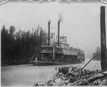
[U.S. Army Corps of Engineers operation to
remove obstacles from the Red River in Louisiana, 1873]: Pl. 107 - Steamer
Bryerly entering Red River through Sale & Murphy's Canal
House Documents, Otherwise Publ. As Executive Documents - Page 706
by United States Congress. House - History - 1875
Home