Improvement of Cypress
Bayou Approved June 10, 1872,
March 3, 1873
|

Improvement of Cypress
Bayou Approved June 10, 1872, March 3, 1873 Part Two
IMPROVEMENT
OF CYPRESS BAYOU AND CONSTRUCTION OF DAMS AND DREDGING AT THE FOOT OF SODA
LAKE, TEXAS.
This
work, authorized by act of Congress approved March 3, 1873. is an extension of
that commenced under act approved June 10, 1872 appropriating $10,000 for
"the improvement of Cypress Bayou, near Jefferson, Texas."
For
report, I divide the work into two parts, as it can best be treated in that
way.
I.
IMPROVEMENT OF CYPRESS BAYOU.
Cypress
Bayou proper is a small stream passing Jefferson, Texas,
and debouching into the head of Fairy Lake, and is thence connected
with Red River by a chain of lakes generally known as the Soda Lakes.
The
work of improvement during the past year has been confined to the bayou. It
has consisted in dredging bars, widening and straightening the low-water bed
of the stream, removing snags, logs, and stumps from the bed, and protruding
logs and overhanging trees from the banks. Incidental to this work there have
been made extensive repair's to the machinery employed.
For
details, reference is made to the following report of the overseer in charge :
DREDGE-BOAT,
Cypress Bayou, Texas,
June
30,1874.
Sir
: In obedience to instructions contained in your letter of May 19, 1874, I
have
the honor to submit the following report of
operations for the improvement of navigation of
Cypress Bayou, Texas, for the fiscal year
ending June 30, 1874.
During
the month of July the dredge was lying at the wharf, city of Jefferson, Texas,
waiting the arrival of the hoisting-drum and machinery ordered of
Messrs.
Atkins & Burgess, of Chicago, to replace the one broken in June. The
engines, machinery, &c., were overhauled, repaired, and put in proper
condition for wont. А new swinging-circle was made for
the head of the mast and put on ; the crane was r«paired and put in order, and
such other repairs about the boat as were considered were made, the work being
done by the crew of the dredge.
The
new hoisting-drum ordered from Chicago did not arrive until July 21.
The
unfinished condition in which the drum and castings were received from the
makers caused a delay of several days in fitting them so that they would work.
the dredging was not commenced till July 29.
It
was the original intention to complete dredging the channel from Boon's Bend, the city wharf, a distance of about three miles. The distance was not quite
two-third dredged when the season of high-water came on and made it necessary
to discontinue
work or move the dredge on the bayou to the more shallow places, which was
done according to instructions received from the late Lieut. E. A. Woodruff.
At
the time of the breaking of the hoisting-drum, in June, the dredge was at work
a short distance below the city wharf, on a shallow point or bar.
During
the interval of waiting the arrival of the new drum from Chicago the water had
fallen so much that it was impossible to get the dredge back down the bayou to
resume operations where the work had been interrupted by the high water
without dredging a portion of the way to that place, the dredge drawing 5 1/2 feet, and at places
there was only 3 1/2 to 4 feet of water in the channel.
Under these circumstances it was deemed advisable to complete dredging the
channel in the vicinity of the wharf. Considerable dredging was necessary to
make a good and permanent channel to the lower end of the wharf, on account of
the bayou being very shallow and having a bend in it. requiring a dredging of
two cuts, or double the usual width the most of the distance, so that boats in
making the bend would have sufficient room and water to do so with very little
trouble.
On
the evening of the 29th of August the hoisting-drum was again broken. Another
one was immediately ordered from Chicago by telegraph.
The
new drum was ordered to be made much heavier and stronger than the one
previously furnished, and to be warranted to stand one year without breaking,
which the makers agreed to do, and to be ready for shipment in ten days from
date of receiving tin' order. Owing to the yellow-fever epidemic at
Shreveport, La., and the establishment of a rigid quarantine on all the lines
of communication to this place, the arrival of the second hoisting-drum was
delayed until October 27. On receiving it on board it was got into position
and dredging resumed as soon as possible.
While
waiting for the drum the crew of the dredge were employed in making repairs
and improvements on the boat, overhauling the engines and machinery, rebabbitting
the journals or boxes of the engine-shaft, and shafts
of the hoisting and swinging drums.
A
new boom was made and put in the crane, a new swinging-chain was put up, the
siphon repaired and new pipe put in, also pipes put up connecting the boiler
with the feed-pump pipes to be used as a
heater to prevent the pipes from freezing up. A new smoke-stack was made and
put over the forge ; a flat-boat was built for carrying wood from the bank to the dredge ; and, among other repairs, a tin roof has been put on
the cabin.
By
the middle of December the channel, from the first deep water below the city
to the lower end of the wharf, was completed, and the dredge moved down the
bayou to the shallow point above the railroad-landing, a distance of about
three-quarter» of a mile from the city, and the dredging out of this place
commenced.
During
the time the dredging of the channel in the vicinity of the wharf was being
done. teams and laborers were employed to remove from the bank of the bayou
some 7,000 cubic yards of excavated earth to prevent its being washed back
into the bayou during the high-water season.
The
earth removed was about two-thirds of the quantity excavated, and that only
that had been thrown out on the right-hand bank while dredging up-stream.
Before the whole of the earth could be removed the water rose, covering the
greater portion it that remaining.
Having
completed dredging the channel between Boon's Bend and the city, the dredge
was taken down the bayou some eighteen or twenty miles to the Benton Cut-offs.
There
are two cut-offs at Benton. Work was commenced on the lower one, it being the
shortest, and, by dredging a channel from 100 to 100 yards in length, cut off
about a mile of very difficult navigation.
The
upper cut-off is considerably longer, and saves following the channel of the
bayou for about the same distance as the lower cut-off.
By
the time I had finished dredging the short cut-off, which was in the latter
part of March, the high-water made it impossible to continue the work any
longer. The probability of the water remaining high for a considerable time
decided me to take the dredge back to Jefferson and have the engines and the
machinery overhauled and repaired, the decks and sides of boat calked and
pitched, and the new crane-machinery, new dipper, and new chains that had
been ordered, and were in Jefferson, put into position. The old dipper and
chains were badly worn and broken.'
In
order to disconnect the old dipper and put the new one in its proper place, it
was necessary to have the dredge by the side of the wharf or some high
bank, as they weigh about 4,000 pounds each, and would be awkward to manage
and get into place without the proper facilities for doing so.
During
the high-water season, which lasted about eight weeks, the dredge was kept
lying at the wharf and undergoing thorough repairs, the crew doing the work.
The
new hoisting and new arm chains were put on, and everything about the boat was
put in as good condition as possible, ready to resume operations as soon as
the stage of the water would permit.
The
water did not recede to the ordinary stage, or within the channel proper, till
about the 1st of June. On the 8th of June I started from Jefferson with the
dredge. down the bayou, for-what is known as "Dorherty's
Defeat," about four mile below Smithland. Here the banks are low, and the
bayou spreads out over the country for some distance, and is quite shallow in
many places, and makes a number of short bends. There are also many stumps
along the channel and in the shallow places that give much trouble to boats,
especially in the low-water season.
That
portion of this bayou called " Dorherty's Defeat" is from one-half to
three-fourth of a mile in length, but the whole distance is not low water,
only in places.
By
dredging a channel through the low-water portions and cutting off several
short points or bars, thereby making the bayou straighter, and removing the
stumps from the channel, the navigation will be materially improved.
After
finishing the work at this place, (Dorherty's Defeat,) which will require two
months time, or more, the next place of any importance in the bayou, between
Jefferson and its mouth, requiring dredging is the upper Benton Cut-offs.
considered it
better to complete the work of dredging the channel of the bayou the dredge
worked toward the lakes.
My
reasons for passing over Dorherty's Defeat, when taking the dredge below late February, was, the water was then too high to work to advantage and
to be able to find and remove all the stumps.
To
cut a channel across the upper cut-off at Benton will take considerable
dredging, as the distance is more than twice that of the cut-off already
dredged.
Upon
completion of the work at Benton no more dredging in the bayou will be necessary, at least for some time, that I am aware of.
However,
there are some places in the bayou where the channel will fill up in a much
shorter time than in others on account of the light sandy nature of the soil
and the peculiar shape of the stream, and, mу opinion, it will
be found necessary to dredge out these localities every year or two.
If
the excavated earth could have been deposited at a greater distance from the
edge of the bank it would have prevented the filling of the channel as soon as
otherwise.
The
navigation of the bayou will be comparatively easy at the ordinary low stages
of the water for steamboats of the class usually running upon these streams.
Judging
from what I have seen and learned regarding the work required in the lake,
especially in the vicinity of the Bois d'Arc Passes and the Blind Bayou, in
the upper end of Fairy Lake, I am of the opinion that navigation could
be greatly improved by working the dredge there, in straightening the
channel, and taking the stumps out. which are the principal obstructions to be
removed. As for the length of time that would be required to do the work at
these places, I could not say.
In
the mouth of February 1,000 pounds of nitroglycerine was purchased for the purpose of blowing up and removing stumps and logs that are in the bottom of
the channel, and are found to be too large and heavy for the dredge to get
out without the risk. of breakage of machinery and loss of time. From the
experiments I have made with it, and the benefit derived from its use in the
work of removing the Red River Kan there is no doubting its efficacy, and I am
confident the use of nitroglycerine in removing these large cypress stumps
and logs will be of great advantage to the work :is the breakage of machinery
in pulling these stumps has caused serious delays.
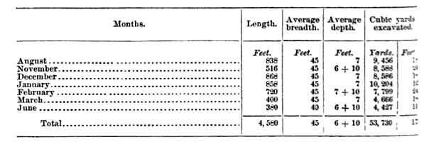
The
following statement shows the amount of excavations made each mouth the dredge
was in operation :
During
the months of July, September, and October the dredge was not at work on
account of breakage of hoisting-drums ; and during the mouths of April, May,
and , part of June, work was suspended by reason of high water.
I
have the honor to be, very respectfully, your obedient servant,
FrANK
W. GEE
Capt. C.W.
HowELL.
Corps
of Engineers, U. S. A.
IL
CONSTRUCTION OF DAMS AND DREDGING AT FOOT OF SODA
LAKE.
In
his report of April 29, 1872, which was a preliminary report on a survey of
Cypress Bayou, and made before the operations of the survey were fully
completed, Lieutenant Woodruff recommended the construction of certain dams,
at the foot of Soda Lake, to confine the
low-water discharge at that point to a single narrow channel or chute. The
appropriation of March 3, it is believed, was based on this recommendation.
In
his final report on the survey, (page G69, Report of Chief of Engineers for
1873,) Lieutenant Woodruff states that the supposition on which he based his
first recommendation he afterward found to be entirely incorrect, and
recommends the substitution of a lock and dam for the dams previously
projected. In submitting this report to the Chief of Engineers, I stated that
I was not prepared to indorse the plan and had directed further investigation.
This investigation Lieutenant Woodruff was directed to make during the season
of extreme low-water in the tall of 1873. Preparations for the work had been
made, and it is presumed that the visit to Shreveport, resulting in his death,
was made by Lieutenant Woodruff with the intention of proceeding with the
examination. Finding himself in the midst of an epidemic ; unable to get
assistants; having been exposed to disease; and unwilling to risk carrying
that disease among his employees at work on Red River raft, he did what was
proper, prudent, and humane, though his action cost him his life. His death
suspended the investigation directed, and it was late in December, 1873,
before a party could be placed in the field to make it.
In
December, Mr. II. A. Leavitt, assistant engineer, was employed to make the
survey, the field-work of which was completed March 10,1874. The work was
plotted, and Mr. Leavitt's report, with plans and estimates, available at the
close of May. It was then too late in the season to commence work on the plan
suggested, even had the amount of appropriation available warranted.
Pending
investigation and survey above reported, it was proposed, in place of dredging
at the foot of Soda Lake, to remove stumps and
logs from the channel through the foot of the lake, and Lieutenant Woodruff
was instructed to avail himself of the first favorable stage of water for
doing this work. For the reasons stated above, the favorable season of 1873
was lost and the project abandoned for the year.
With
the light we now have it must appear well that money has not been expended on
either of the three projects named above.
It
is now possible for me to submit a definite plan for the improvement desired,
and in doing so I will first present a description of the navigation from
Jefferson to Shreveport, and afterward a discussion of the several plans for
improvement that have been considered.
DESCRIPTION.
Jefferson,
Texas, is at the head of navigation in Cypress
Bayou. From that point down to the head of Fairy Lake, a distance of
twenty-seven miles, the Bayou, at low-water, is narrow, tortuous, and before
improved was shallow and greatly obstructed by timber. Fairy Lake, from its
bead for about half its length, is thickly studded with cypress-trees, stumps,
and fallen timber, through which the old channel of Cypress Bayou may yet be
traced at low-water, and this, if cleared of logs and stumps, would afford
low-water navigation of about 2 feet.
In
high-water this channel is partly followed by steamboats, and
partly avoided by use of what are known as " cut-roads." The lower
half of the lake affords a navigation of over 6 feet.
At
its foot the lake enters the valley of Red River between bluffs but 1,480
yards apart. At this point it meets the whole discharge from Red River that is
made by the latter through breaks in its western bank between Hurricane Bluff
(directly opposite the foot of the lake) and Blanton's Landing, twenty-two
miles above.
January
l, 1872, when at Albany Point, the water-surface was 6 feet above extreme
low-water; the surface, at this point was found ±3 feet below the surface of
Jefferson, (twenty-five miles distant in a straight: line, 38 feet below the
surface of Red River at I> hut ton's Landing, (twenty-two miles distant,)
and 11 feet below that at the nearest point on Red River, (five miles distant^
The
great body of water concentrated at this point finds vent through Willow Pass
into Soda Lake, giving the pass a depth of from
20 to 00 feet, but at its foot, where the water spreads into Soda
Lake, forming a bar having over it only a depth of about - feet at low
water. Through the lake there is a depth of from 3 to 3 feet, and at its foot
a wide shoal. known as Albany Flats, with a depth of but 1 foot at extreme low
water.
This
lake forms a settling-basin for the Red River water drawn through: it. The
slope of its water-surface at the date before stated was but L1
inches to the mile. It is gradually filling up with Red River deposit.
Below
Albany Point the old channel of Cypress Bayou is well defined, and affords
good low water navigation through the upper portion of Cross Lake, Twelve-mile
Bayou, and Red River, to Shreveport.
At
Albany Point, January 1, 1872, the, surface of the water was 6.3 feet below
the surface in Red River at the nearest point, 2.3 miles distant. At the
head of Twelve-mile Bayou the water-surface was 2.8 feet below Red River
opposite, a distance of 704 yards.
The
fall from Albany Point to Shreveport was 11.8 feet ; from Red River, opposite
Albany Point, to Shreveport, 18.1 feet.
From
this it appears that the foot of Fairy Lake is the center of a basin, having
Red River on one, side and the line of bluffs to the west of it on the other.
[This is better shown by the chart enclosed, marked
(A)-]
The
raft in Red River, along the eastern rim of this basin, deflected the greater
portion of the river-discharge above the raft into the basin. thus
converting what before the advent of the raft was a cypress-swamp, with a
sluggish, unnavigable stream flowing through it, into a series of lakes,
affording good navigation for the greater portion of each year.
It
is feared on the part of the commerce interested that the removal of the raft
will immediately effect a shortening of the season for this navigation, and
perhaps ultimately return it to its original condition.
It
is too early to determine if such fear be well grounded.
It
is desirable at present to obtain a 3 foot low-water navigation through
Shreveport to Jefferson ; this is probably as much as will ever be required.
To obtain this the following plans have been considered :
1st.
Dredging.
2d.
Wing-dams at Albany Point.
3d.
A lock and dam at Albany Point
4th.
A tumbling or other dam at Albany Point, with a cut into Red River.
6th.
A dam across Willow Pass, at the foot of Shirt-tail Lake, and the re-opening
of Irishman's Bayou.
6th.
A dam in Cross Lake and Twelve-mile Bayou, with a cut from near the head of
this bayou to Red River.
The
following consideration of these several plans is submitted.
 `
`
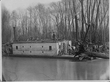
U.S. Army Corps of Engineers
operation to remove obstacles from the Red River in Louisiana, 1873]: Pl. 17 -
crane boat at work [removing dead tree]
DREDGING.
Beginning
at Albany Point, on a straight Hue through Soda Lake, the distance to deep
water in Willow Pass is about eight miles ; over this line the depth at
low-water varies from 1 to 5 feet. This is the line that apparently should be
adopted for a dredged channel through the lake, for the reason that, except
through a very short portion of the lake, (about one-quarter its length,) the
old channel of Cypress Bayou has been obliterated by deposit, while that
portion that may yet be traced is so narrow and tortuous that it would require
widening and straightening by dredging to put it in good condition.
Dredging
on the straight line indicated, to obtain a 3-foot channel, would require
excavation to a depth of about 2 feet for one mile over Albany Flats, and
excavation of about 1 foot, for the same distance, at the foot of Willow Pass
; a total excavation of about 3.5,200 cubic yards for a channel 60 feet wide.
The
excavation would run through the remains of a Cypress Swamp, and would
consequently be very expensive. Further, it has been shown by the surveys made
that Soda Lake is the main settling-basin for
the Ked .River water passing through it.
The
deposit in this lake has been so great as to entirely cover the knees of the
cypress yet standing in the lake, while in the other lakes these knees are yet
uncovered.
The
depth of such deposit was not ascertained, nor is it known for how long a time
it has been forming, but the covering of cypress-knees indicates a thickness
of several feet, and the living trees at points in the lake show it to be a
very recent formation. The inference is that since the cause of deposit does
and will continue, any dredged channel through the lake must sooner or later
be silted up. If, then, dredging be resorted to, the depth should be made
considerably greater than actually necessary for the time being, in order to
avoid annual dredging to keep the channel open.
I
assume, therefore, that the depth of a dredged channel through Soda
Lake should be G feet at extreme low-water; this would make an average
dredging of about 2 feet, sixty feet wide, for a distance of eight miles,
equal 563,200 cubic yards of excavation. This, of itself, appears sufficient
to condemn dredging, but when there is added to it the dredging that would
have to be done in the upper end of Fairy Lake and across the bar at the
present mouth of Cypress Bayou, it is clear some other plan of improvement
should be considered.
WING-DAMS
AT ALBANY POINT.
This
was Woodruffs first recommendation. He afterward found that the chutes he
proposed to close with dams were so nearly dry at low-water that but little,
if any, concentration of low-water discharge would be effected by the dams,
and that consequently they would be of little or no use in holding the last
stages of a flood in Soda Lake to prolong
navigation through it.
LOCK
AND DAM AT ALBANY POINT.
This
was recommended by Lieutenant Woodruff in his final report of survey of
Cypress Bayou, and the plan was well calculated to give at all seasons a depth
of 11 feet from Albany Point to Jefferson. Having doubts of its low-water
effects below Albany Point, I have awaited the results of the further survey
ordered before considering the project.
The
survey of Mr. Leavitt, besides disclosing difficulties of foundation not
anticipated by Lieutenant Woodruff, shows that without the inter position of a
second lock and dam between the first and Shreveport. is low-water the bayou
and lake below Albany Point, for a distance of nearly 6 miles, would run dry.
This is best shown in section on Leavitt's chart herewith, (marked B.)
The
first lock would require a lift of 10 feet, the second a lift of 13 feet, at
low-water of 1873 at Shreveport, to make 3-foot low-water navigation from that
point to Jefferson.
The
walls and gates of the locks would have to be 26 feet high in order not to be
overtopped at a stage of water equal to the high-water of 1866, the highest
of which we have record.
In
view of the above, the project was rejected, and it was not considered
necessary to make detailed plans and estimates for it.
DAM
AT ALBANY POINT AND CUT INTO RED RIVER OPPOSITE.
Woodruff's
survey showed the whole fall from Jefferson to Albany Point to be but 3.5 feet
at a time when there was 4-foot navigation on: Albany Flats. Of this fall, 2.3
feet was from Jefferson to the head of Fairy Lake. The lake was a level; from the
foot of the lake to Albany Point the fall was 1.2 feet.
By
placing directly across the water-way at Albany Point a dam having its crest
14 feet below the local high-water mark of 1866, that will be given over
Albany Flats a depth of about 6.5 feet, whence. than' the above, it is
evident there will be given to the foot of Fairy Lake.) least depth of 5.3
feet, and from thence to Jefferson a least depth of ' feet throughout the
year.
It
is considered that the latter depths will be greater than stated; the reason
that the slopes reported will not probably be very greatly diminished ; also, no
allowance is made for the dredging from Jefferson to the head of Fairy Lake, a
distance in which the greater fall occur for the reason that it is
anticipated that the dredged places will fill in j few years.
For
perfect safety the figures are based on a level from Albany Point to Jefferson.
As
such dam. while answering the purpose of giving good navigation above it to Jefferson, would effectually cut off the navigation
below from that above, it
would be worse than useless, except a new connection
be made with Red River. A cut to Red River from a point above the dam is
therefore necessary as a portion of the project.
The
difference in level of water-surface between Soda Lake
at Albany Point and of Red River (opposite) at Gold Point renders
such connection practicable without lowering the surface created by the dam,
as shown by the following:
Our
surveys indicate the, fact that during all seasons of the year the surface of the lake at Albany Point is lower than the surface of the
river opposite at Gold Point, viz, at high-water of 1866, when there was
between 19 and 20 feet over Albany Flats, the lake-surface was 2.33 ft: below
that of the river.
In
1872, with 4 feet over the flats, it was 6.3 feet below; and in 1867. with
between 2 and 21/2 feet over the flats, it was 3.8 feet below.
Although
no observation was made to determine the difference of level at extreme
low-water, viz, when there is but one foot of water over the flats, it is
assumed that this difference is probably not less than 2 feet- in
as much
as the measurements given were all made before the removal of the raft.
Under
this assumption the proposed dam and cut should give at all seasons of the
year 3 feet navigation over Albany Flats, a sufficient depth for the present,
since the river below Shreveport only affords a depth of 20 inches during
low-water; and it is not the local trade between Shreveport and Jefferson that
is to be served by improvement, but the trade between the Mississippi River
and Jefferson.
Besides
the improved navigation it is designed to give above Shreveport, this project
presents another subject for consideration.
It
is claimed that in case the removal of the raft should prove to effect a
shortening of navigation through the Soda Lakes, it will also shorten the
season below Shreveport.
This
is on the supposition that the lakes serve as reservoirs to detain floods of
Upper lied River, so that they are longer in passing Shreveport than they
would be if these reservoirs did not exist. If this be true, then the
reservoirs are useful in lengthening the season of navigation below them.
The
plan of a dam and cut at Albany Point appears to present the means not only
for preventing any possible deterioration of these lakes as reservoirs, but
also a probable means for increasing their efficiency.
In
connection with this three plans for a dam have been considered, and these
require notice.
1st.
A tumbling dam, having its crest 14 feet below the local high- water mark of
1866. This is the one so far assumed for illustration, and the one called for
if navigation above it is alone to be considered.
In
this case there is but one objection to it, and that may be overcome by a
suitable construction. The objection is this: The character of the foundation
offered for a tumbling dam is not favorable to permanence of the structure,
the soil being of an easily abraded mixture of sand and clay, with strata of
sand at intervals. During low-water the bed of the lake at the foot of the dam
will be dry, while just above, on Albany Flats, there will be from 3 to 0
feet.
At
the commencement of a rise, when the water begins to flow over the dam, the
fall over the several portions of the length of the dam will range from zero
to 15 feet. It will afterward be some time before the lake below fills
sufficiently to afford a useful water-cushion to break this fall. At extreme
high-water the surface of the upper lake will be from 10 to 14 feet above the
crest of the dam, and the lake below will probably be filled to nearly the
same level; during the intermediate stages we must expect powerful eddies
about the foot of the dam.
These
facts suggest difficulties of construction which may certainly be overcome,
but at great expense, and by taking every precaution to have workmen and
material on hand so as to begin and complete the work in a single low-water
season, the length of which may only be safely assumed at 4 mouths, and those
4 months the most unhealthy of the year.
If
we further look to this dam as a means for increasing the efficiency of the
Soda Lakes as reservoirs, then it must appear too low to have any appreciable
effect, for it has been shown that during all except the lower stages, water
must run from Red River to the lake rather than from the lake to the river,
while after the lake has fallen to the crest of the dam, and further discharge
must be into the river, the possible fall of three feet, taken in connection
with the area of the lake, indicates such a small volume of discharge that it
does not nee«! figures to prove it of no value below Shreveport.
2nd..
A dam from Albany Point to the bank of Red River, having its crest 2 feet
above the high-water of 1866, on Red River..
As
the first plan of dam is the minimum allowable for improved navigation, so
this plan appears to offer a maximum for reservoir effect.
It
would throw the whole of the lake discharge into Red River through a channel
which (following its meanderings) would he 7.6 mile longer between Albany
Point and Shreveport than the present route via Twelve-mile Bayou, and 9.1
miles longer than the route via Cross Bayou.
This
difference in length would necessarily retard the emptying of the reservoir,
but on the other hand we should lose an important portion of the present
effect of Lower Cross Lake. The latter would then be only a reservoir in
proportion as the water was ponded back in to it: from Shreveport, whereas now it
holds a large volume of the flood-water received through the Soda Lakes, for a
time after the latter have well run out. This is evidenced by Leavitt's
survey, and a section display' on his chart, where it is shown that the
water-surface in the neck between Upper and Lower Cross Lake was 3 feet
above the surface on Twelve-mile Bayou, 540 feet distant, and the same
above Red River. just above.
It
is questionable if the gain on the one hand would not be balanced by the loss
on the other.
There
is another and more serious objection to the plan, viz: IV river between the
dam and Shreveport has not the capacity to cam the volume to be added from
the lakes, and to give it the capacity won:<¡ require radical changes in
its bed, involving the destruction of many plantations.
These
two considerations condemn the plan of a high dam.
3d.
A dam across the foot of Soda Lake, having its
crest of the height of No. 2 ; the
crest between the lake and river to be depressed to 9 feet below
the high-water of 1866.
This
is a compromise between the 1st and 2d, and while offering the advantages
possessed by both, permits the filling of Cross Lake by direct overflow, and
it is thought will not seriously affect the plantations along the river bank.
This
is the plan recommended in my communication of May 1, (remitted to the Chief
of Engineers in answer to the inquiries of the chairman of sub-committee of
House of Representatives on rivers and harbors
It
is the plan I recommend for adoption on two conditions, viz:
1st.
That the money required to carry it out be all appropriated before the work is
commenced.
2d.
That the commerce to be benefited be found to warrant expenditure. Of this I
do not pretend to judge.
The
other two plans considered call for but brief mention.
5th. The
fall from Red River, through Irishman's Bayou, to the foot of Fairy Lake,
January 1, 1872, was 11 feet. It is evident that crossing the head of Soda
Lake, Willow Pass, passing around the of Shift-Tail Lake, and connecting with
the bank of Irishman's Bay might be constructed the same as at Albany Point, and
to answer same purposes.
The
length of the dam. as indicated on Woodruff's chart, and great height, due to
the depth of Willow Pass, together with the labor of reopening Irishman's
Bayou, which is filled with raft, shoal, ' and tortuous, condemns the project,
further by cutting oft" the settling basin afforded by Soda
Lake, a great deposit would be induced above the dam, making in a short time, it is
anticipated, a second Albany
6th.
Mr. Leavitt suggested a dam across the neck between Upper and Lower Cross
Lakes, thence across Tweh'e-mile Bayou to the bank of Red River, and a cut
from the bayou above into the river. This was rejected because of the
dimensions of the dam required and the insufficient fall from the river to the
bayou, the latter being so slight that it could not have effected the depth
over Albany Flats.
The
location at Albany Point appears to be a proper mean between the two locations
last named.
Home