The
commercial use to which the rivers of Texas have
been put has varied greatly at different times in the State's history. In the
early days before the railroad era, when the choice of the settler lay between
the river boat and the ox-cart, the rivers were of considerable commercial
importance. The Red River supplied an outlet to New Orleans for the
northeastern portion of the State, the traffic of this section passing out by
way of the town of Jefferson, down Cypress Bayou, across Lake Caddo to the Red
River. Navigation above this point on the Red River was interfered with by
what was known as the Great Raft, an accumulation of drift wood which blocked
the channel for many miles near the town of Fulton, Arkansas. Above the Raft
small boats were used as far up as Preston in Grayson county.
In
South Texas, most of the commerce of the coast
country passed in and out along the rivers and arms of the sea. Before Texas
revolted from Mexico, a steamboat was making regular trips on the
Brazos, and in the early fifties the Galveston and Brazos Navigation Company
opened a canal connecting Galveston Bay with the Brazos, thus bringing the
products of Brazoria and adjacent counties to the wharf at Galveston. In this
way it was estimated that a saving of $50,000 annually in freights and
insurance was effected. Richmond was at the head of regular navigation, though
occasional trips were made as far up as old Washington, near the present site
of Hempstead. Galveston Bay and Buffalo Bayou furnished water connection
between Houston and Galveston, and four steamboats were engaged in this trade
as early as 1838.2 The Trinity river was
regularly navigated to Liberty, seventy-five miles from Galveston, and
occasionally as far up as Magnolia, some ten miles west of Palestine, but
Rankin's statement that "the river may be successfully navigated with but
little difficulty from six to nine months in the year, for 300 miles by land,
and 500 by the course of the river,
seems to have been one of those loose exaggerations of which we find many in
the early descriptions of Texas and her
resources.
The
Sabine Lake and the Neches and Sabine rivers furnished a modicum of
transportation facilities for the lumber and cotton of
the southeastern section of the State. The situation in this region is well
stated in a letter written in 1843 by S. H. Everitt to Anson Jones, afterwards
President of the Republic. He said, "There must be some place for the
receiving and forwarding of the cotton of Texas at
the mouths of the Neches and Sabine. The Sabine pass is not suitable, because
flat boats coming down the river cannot cross the lake with safety and that,
and keel boats, are the only kinds of boats that can at this time come down
the river Neches, and it will require much labor before steamboats can
navigate the river. Cotton can be brought down the river from Jasper county at
an expense of $1.00 per bale, and from Nacogdoches for $1.50 to $2.00; while
the expense of shipping to Natchitoches (on the Red River in Louisiana) is
from.$5.00 to $7.50 per bale, and the expense on a bale of cotton shipped to
New Orleans from Natchitoches is quite as much as it would be to ship
the bale of cotton from Sabine Lake to
New Orleans, or to Galveston."
The
facilities for navigation on the southwestern coast were confined mainly to
the Gulf and its inlets, Matagorda, Aransas and Corpus Christi bays. The
Colorado had at times been navigated as far up as Austin, but in 1850 Rankin
reports that "steam-boating is not now successfully prosecuted on account
of the unimproved condition of the channel.
The Guadalupe was used occasionally up to Victoria, and steamboats plied on
the Rio Grande as far up as Rio Grande City,"' though Rankin assures us
that "the stream at present is navigated by steamboats to a distance of
about 500 miles.
II.
Early Attempts at River Improvement.
Prior to the Civil War the" State made at least one serious attempt to
improve the .Texas rivers and bays along the
coast so as to render them more serviceable to the rapidly increasing trade of
the State. As early as 1839 the treasurer of the Republic paid from his empty
coffers a warrant for $520 expended in surveying the harbors on the Gulf coast In his message to the Fourth
Congress,
November 12, 1839, President Lamar urged the establishment of a new
department, to be known as the Home Department, one of whose duties should be
the supervision of the proposed road building and river improvement. In 1852 a
bill was introduced into the State Senate appropriating some $250,000 for
river improvement. Four years later the work was entered upon in earnest, the
treasury stringency having been relieved by the money received from the
Federal Government as a result of the adjustment of the New Mexico boundary
dispute. An act was passed in 1856, carrying a total sum of $315,000 to be
used on river and harbor improvement. It provided for the appointment of a
State Engineer, who was to have control of the work and who, with the Governor
and Comptroller, composed a board for apportioning the funds to the various
projects. Bach locality was required to raise by subscription one-fourth the
amount allotted to it by the board.
The
following table8 shows the contracts approved
by the board up to 1858. Two or three other places had raised the required
funds and their contracts were pending:
| River.
Section.
Consideration. |
| |
|
Guadalupe
Mouth to Victoria $22,850
Western
Bays Matagorda Bay to Aransas and Guadalupe rivers 57,500
San
Jacinto Clapper's
Bar
22,725
Trinity
Bar at mouth 15,120
Brazos
Mouth to Washington 50,000
Colorado
Canal around raft 35,000
Colorado
From raft to Wharton 11,250
Cypress
Bayou... . Jefferson to State Line 21,298
Oyster
Creek Canal to Retrieve 3,833
Sabine
Up to Logansport 31,455
Galveston
Bays To Canal and Red Fish 23,000
|
This
work progressed satisfactorily during the next two or three years and by the
beginning of the Civil War river navigation had reached its high water mark.
In 1859, a writer says "A considerable portion of the cotton made in
Shelby county was shipped down the Sabine river this season. The people in
this section of
the country, in view of the improvements going on to open up the Sabine river,
are much pleased with the probability of being able hereafter to turn their
entire trade to New Orleans and Galveston, through this channel. The
steamer 'Uncle Ben made five successful trips, two of which were as high up
as Smith county, a distance of nearly 800 miles, carrying out nearly 1000
bales of cotton each trip. Also the 'Pearl Plant' and other boats have done
considerable in the Sabine trade, and without the least difficulty from
leaning timbers. I have no doubt that 60,000 or 70,000 bales of cotton
will find its way to market next season through this channel to New Orleans
and Galveston.
With
the outbreak of hostilities, the efforts at river and harbor improvement
ceased and all the energies of government and people were turned in another
direction. As a result the channels became clogged, commerce declined and
river navigation almost ceased. After the war there were a few attempts by
private parties to clear the rivers and revive the river trade, but they were
only partially successful. The rapid
construction of railways after 1870 largely removed the incentive to river
improvement. Most of the streams have ceased to be factors in the
transportation problem of the State, though considerable quantities of cotton,
lumber and other low grade freight are still floated down the rivers to the
Gulf ports. It remains to be seen whether the efforts at canalization now
being made by the United States Government will succeed in making the Trinity,
the Brazos, and other Texas rivers successful
rivals of the railroads.
III.
Overland Trade and Travel.
Before
the advent of the railway, overland trade and travel were accomplished by
means of the ox-wagon and stagecoach. The roads were
few and poor; road building for the most part consisted merely of clearing the
brush from the right of way and log- bridging such streams as could not be
conveniently forded. Several
efforts were made by the Republic to build national highways. In 1838,
commissioners were appointed to open a road from Bastrop by way of the upper
three forks of the Trinity to a point on the Red River not below Spanish Bluff
nor above the Cross Timbers. In 1839, the
House passed a bill to reopen the old road from San Antonio to Nacogdoches,
but it died in the Senate. Another House bill, providing for opening a
national road from Washington on the Brazos to the Sabine, produced a very
warm debate in the Senate. Several members opposed the bill because it
appropriated for the enterprise $500 from the national treasury. Where was the
money to come from? Said one patriot, "We have an army, a navy, and all
the officers of government to pay, soldiers to clothe and feed, Mexicans and
Indians to whip, and to guard our frontier—uses, in fact, for ten times as
much money as we can raise." Others opposed it because they believed it
was an attempt at class legislation, and that it was prompted by the local
greed and grasping spirit of Jasper county. The result was that when the bill
became a law the $500 appropriation had been eliminated and the counties were
left to open the road at their own expense.
Another attempt at highway building occurred in 1844 when Congress provided
for opening the "Central National Road of the Republic of Texas."
It was to run from the mouth of the Elm Fork of the Trinity to a point
on Red River opposite the mouth of the Kiamisha. The road was to be located
and surveyed and then let out to contractors, who were to be paid for their
work by a grant of public lands, provided that the cost of the road should not
exceed one hundred and sixty acres of land to the mile. The road was to be
thirty feet wide, the bridges fifteen feet wide, and the stumps not more than
twelve inches high.
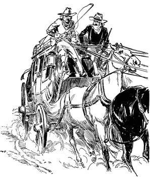
As
the population increased, the counties gradually opened roads
to accommodate the traveling public, and private stage lines were
established between the principal towns. These stage lines were the
forerunners of the railways, and served as models for the early railroad
companies. They were usually owned by an individual or company called the
"Contractor." The roads over which the stagecoaches traveled were generally laid out and surveyed
by
the Contractor, but they were kept in repair by the counties through which they passed. Depots were established in all the
important towns on the routes and tickets for transportation were sold as is done by the railroad companies of today. The teams
consisted of from four to six horses or mules. An average
speed of five to eight miles per hour was made, but it is said that in bad weather the passengers were sometimes compelled to walk
and prize mud from the wheels. Fresh teams were secured from time to time at stations scattered along the route and taverns
and
eating stands were provided for the refreshment of the passengers. The usual cost of transportation was ten cents per mile,
each passenger being allowed a small amount of hand baggage.
The number of stage lines in Texas probably
reached a maximum limit about 1860. The Texas Almanac
of that date shows thirty-one
distinct stage lines, forming a perfect network of lines that covered all the settled portions of the State. It is a matter
of interest to note that a strong tendency toward consolidation had made itself felt even at this early date, for we find that one
concern, the firm of Sawyer, Fisher, and Hall, controlled sixteen of the thirty-one lines. They were believed to be the largest mail
contractors in the United States, owning many lines in Louisiana as well as most of those in Texas, and
employing three hundred men
and one thousand mules and horses.
In
addition to the thirty-one lines lying within the State there were two long
distance lines in operation that deserve mention. One extended from Sherman to
Fort Smith, Arkansas, where it made connection with a line to St. Louis. The
through trip from Sherman to St. Louis was made in four and one-half days, traveling
day and night. This line also extended from Sherman to Fort Concho,
near the Rio Grande, where it made connection with the line from San Antonio
to San Diego, California.
This
latter route from San Antonio to San Diego was one of the longest overland
stage lines ever established, covering a total distance of fourteen hundred
and seventy-six miles. It was opened in 1857 by Mr. J. E. Burch, of
California, who secured a contract with the Post Office Department to carry
the mails between the two places, semi-monthly trips to be made in four-horse coaches,
the consideration being $149,000 annually. Although thirty days were allowed
for the trip, the mails were rarely out over twenty-five days, twenty three
days being the average time required. The cost of a through passage was $200,
all expenses being borne by the company. The stages were so arranged
"that passengers could recline in them comfortably and take their sleep
while traveling." In carrying out this contract the company employed
sixty-five men, fifty coaches, and four hundred mules.
The San Antonio and San Diego route was, without a doubt, the most practicable
route to the Pacific, and, had it not been for the prejudices of the Civil War
period, it would probably have been chosen as the route for the first
transcontinental railroad. It is interesting to note how closely the old stage
route was followed, fifteen years later, by the engineers of the Southern
Pacific Railway Company.
The
transportation of freight was accomplished by means of ox freight-lines, which
in general followed the routes used by the stage lines that led to the markets
and seaports. A caravan of ox-wagons moved along at a very leisurely pace,
depending on the grass along the way for the support of the teams. Many weeks
and even months were required to deliver a cargo of cotton or buffalo hides at
the market and to return to the interior with the sugar and coffee and
manufactured goods required by the settlers. Before the opening of roads
the cost of transportation was almost prohibitive. In 1842, President
Houston assigns the cost of transportation, along with the danger from
Indians and Mexican raiders, as a cause for the removal of the capital from
Austin to some point near the sea-coast. "During the last year,"
said he, "the expense to the government for transportation to the city of
Austin, over and above what it would have been to any point on the seaboard,
exceeded seventy thousand dollars, and the extra cost of the transportation of
the mail, aside from all other expense and inconvenience attending its remote
and detached situation, amounts to many thousands more.
As
the country became settled, however, "freighting" came to be a
permanent occupation and furnished employment to a very considerable portion
of the population. The customary rate of charge was one dollar per hundred
pounds per hundred miles, or twenty cents per ton-mile, if we express it in
terms of the modern railway unit of work. As the present freight rate in Texas
is about one cent per ton-mile, it will be seen that the introduction
of the railway has reduced the coat of transportation to about one-twentieth
of what our fathers were compelled to pay. This heavy cost of
transportation was a tremendous handicap on the fertile black-land region of
the central and northern sections of the State. The surplus wheat of this
region, on account of the cost, could not be transported over a hundred and
fifty miles, and either rotted in the fields or was fed to the stock. It was
undoubtedly this lack of transportation facilities that caused this, the most
fertile region of the State, to remain so long practically untouched, while
the population fringed the Gulf and bays and navigable rivers at the southern
and eastern sections.
"The
Comptroller's Report for 1850 shows sixteen counties whose assessed wealth
exceeded one million dollars. They were all in South and East Texas
and practically all were located on navigable water. Following are the
assessed values for 1850 income of the typical counties in Central and North Texas
on the one hand and in South and 'East Texas on
the other:
.
|
Central
and North Texas
Counties—Assessed Values |
South and East Texas Counties— Assessed
Values. |
| |
|
|
Bell
$96,000
Collin
159,000
Cooke
' 8,000
Dallas
145,000
Denton
16,000
Ellis
84,000
Falls
40,000
Fannin
538,000
Grayson
183,000
Henderson
10,000
Hopkins
227,000
Hunt
87,000
Kaufman
82,000
Navarro
266,000
Tarrant
30,000
Williamson
353,000
Total
$2,324,000
|
Austin $1,235,000
Bexar 1,069,000
Brazoria 3,236,000
Fayette 1,032,000
Fort Bend 1,060,000
Cass 1,022,000
Galveston 2,242,000
Grimes 1,208,000 /
Harris 1,676,000*
Harrison 3,099,000
Matagorda 1,323,000
Natogdoches 1,743,000
Rusk 1,717,000
Red River 1,002,000
San Augustine 1,587,000
Washington 2,102,000
Total $26,353,000
|
The
total assessed wealth of the State for that year was $50,715,000, of which it
will he seen more than one-half was located in the sixteen counties of South
and East Texas, just enumerated.
IV.
Early Trade Districts and Trade Centers.
In
the days of the "freighters," Texas was
divided geographically into five trade districts, each tributary to one or
more market towns and seaports. The boundaries of these districts overlapped
each other and shifted from time to time, but the districts were distinct and fairly definite. The most important of these districts was that tributary
to Houston and Galveston. Roughly speaking, it had the Neches for its eastern
boundary and the Colorado for its western boundary, and it extended northward
to the Red River. The region lying to the east of the Neches and south of
Nacogdoches and Shelby counties sent most of its products to the Galveston and
New Orleans markets by way of Sabine Pass, though at times considerable trade
crossed the Sabine to Natchitoches and other Red River points for shipment to
New Orleans. Lying west of the Colorado and south of Erath and Eastland
counties was a great, relatively unsettled region whose chief market was San
Antonio, and whose seaports were Port Lavaca, Indianola, Matagorda, Texana,
Saluria, and Corpus Christi. The trade of the Rio Grande valley as far
northward as the San Diego stage line, centered in Brownsville and Brazos
Santiago. The fifth district stretched from the Red River across the northern
portion of the State to the frontier counties in the west. Its chief market
and port was the town of Jefferson, which was connected with the Red River by
Cypress Bayou and Caddo Lake. Shreveport was a strong rival of Jefferson,
while Clarksville was the leading distributing point for the commerce on the Red River
above the Great Raft.
The rival cities of Houston and Galveston took their rise at the same time,
during the period immediately following the Texas revolution
in 1836. Galveston has always been the chief seaport on the Texas
coast, while Houston at the head of navigation on the Buffalo Bayou
early came into prominence as a distributing center, In 1836 Galveston had
hardly one vessel per month. In 1838, vessels were coming and going daily and
the imports during the first quarter of the year amounted to more than a
quarter of a million dollars. A writer in the Houston Telegraph, June
16, 1838, says that Galveston then had fifty or sixty elegant buildings, where
there had been only one twelve months before. In a public address in
Galveston, June 29, 1839, Dr. Anson Jones, afterwards
President of the Republic, said: "I am happy, fellow citizens, to see the
evidences of prosperity which now immediately surround the island of
Galveston. It is but about eighteen months since the improvements commenced on
this island; and now, after the lapse of so short a time, the city of
Galveston, like Venice, the bride of the Adriatic, has arisen as if by
enchantment from the waters, and smiles gloriously and beautifully upon the
sea which surrounds her. Your population, which already amounts to near three
thousand, is rapidly and constantly increasing." The population had grown
to 5000 in 1850 and to 15,000 in 1865. despite the ravages of the Civil War.
The exports through the port of Galveston, which amounted to $23,000,000 in
1865, had grown to ten times that figure in 1907.
Houston's
growth kept pace with that of Galveston until after the war. Then, as a result
of its railway connections and the establishment of manufacturing
enterprises it gradually forged ahead in wealth and population, and as an
inland trading center.
The
principal seaports for San Antonio and the region west of the Colorado were
Port Lavaca and Indianola, rival towns on Matagorda Bay.18
The population numbered about 3,000 and 2,000 respectively in 1860. In that
year Port Lavaca exported 30,000 bales of cotton and Indianola 28,600. Another
rival port in this section was Corpus Christi, whose population in 1860 was
about 4,000. In 1875 Indianola was completely overwhelmed by a great tropical
storm similar to the one that visited Galveston in 1900. Today only a single
boat house marks the spot where this flourishing seaport once stood.
Brazos
Santiago was mainly engaged in trade with Mexico, nearly four million dollars'
worth of imports coming from that country in 1859. Of this amount, however,
more than three million dollars consisted of silver bullion. Sabine Pass, on
the other hand,
was mainly engaged in the export trade. In 1859, the exports from this port
were 18,000 bales of cotton, 1,099,000 feet of lumber, 12,000,000 shingles,
7,000 hoop poles, 97,000 staves, 5,669 beeves, and 23,700 pounds of tobacco.
The imports during the same year were about 100,000 barrels of assorted
merchandise.
In
the history of the early commercial struggles in Texas,
there is no story more pathetic than the rise and decay of the town of
Jefferson. Before the railway era it was by far the largest city and trading
center in North Texas, and second only to
Galveston as a shipping point. Cotton, wheat, hides, and lumber, all the
surplus products of a region as large as many of the States of the Union,
sought their way, on slow-moving wagon trains, to the wharves of Jefferson,
where they were loaded on small steamers that threaded their way through the
tortuous channel of the Big Cypress, across Lake Caddo, and down the Red River
to New Orleans and the commercial world beyond. On the return trip the
steamers brought to Jefferson the manufactured goods of other sections and of
foreign lands, which were distributed westward to Sherman, Dallas, Fort Worth
and other frontier settlements to the foot of the plains. It is estimated that
at one time one- fourth of the entire trade of the State passed through
Jefferson. For the years 1859 and 1860 the export cotton trade of Jefferson
amounted to 88,000 bales and 100,000 bales respectively, while the exports
from Galveston were 118,000 bales and 148,000 bales for the same years. The
wagon trade was so large "that the roads leading
from the west were literally so blocked up with vehicles that passage was
difficult.
But
a change came with the building of railways into Jefferson's trade district.
In the early seventies, the completion of the Houston & Texas
Central to Dallas and Sherman furnished an outlet to the Gulf, the main
line of the Texas and Pacific gave an outlet to
New Orleans by way of Shreveport, and the Transcontinental Branch, connecting
with the Iron Mountain at Texarkana, gave a direct line to St. Louis. The
little river steamer and the ox- wagon proved no match for the locomotive. New
commercial centers sprang up in the west and Jefferson's wagon trade began to
decline. Her enterprising business men made a strong fight to hold
the trade they had so long enjoyed. They organized themselves into a railway
company and built a narrow-gauge line west through Sulphur Springs to
Greenville, and later to McKinney. They built a saw mill, an iron foundry, an
oil refinery and a wagon factory. But they
fought a losing battle. "The building of the Texas
and Pacific worked an era of decline for Jefferson, which has
depreciated her property seventy per cent since 1874, forced half her
population to move away, left her finest buildings without a tenant, and
partially made her the Palmyra of Texas. Railroad
competition for freight has forced steamboats out of the bayou, which they
rarely or never ascend as in former days, but stop at Shreveport.
Her population decreased from 12,000 in 1870 to less than 5,000 in 1880, and
to 3,000 in 1890.
Clarksville
had a career similar to that of Jefferson, but somewhat less dramatic. A
writer in the Galveston News of September 1, 1881, says: "This,
the oldest town in Northern Texas, was begun in
1835, and up to 1860 continued the leading place in that section, and was such
in 1842 when neither Paris, Dallas, nor Bonham had an existence. It was to
North Texas what Jefferson was to the eastern
part of the State, and commanded the trade of a most extended section, then
but sparsely settled and little known. Before the days of railroads in Texas,
Clarksville procured its supplies from New Orleans by way of Red River,
steamboats delivering their cargoes at Rowland's Landing, fifteen miles
distant, from which point wagon transportation was used. Clarksville is said
to have sold and distributed her goods as far west as El Paso. Like Jefferson,
the trade of the town came to a stand-still simultaneously with the railroad
era, because most of the country tributary to Clarksville then began to
patronize other markets opened up."