- U.S. Army Corps of Engineers: Lake O’ the Pines
- U.S. Army Corps of Engineers: Corps Lake Gateway: Lake O’ the Pines
- Recreation.gov: Ferrells Bridge Dam Lake O’ the Pines
- GORP: Parks: Lake O’ the Pines – (Ferrells Bridge Dam) – Texas Corps Projects
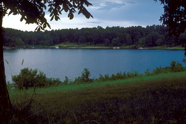
 Ferrells
Bridge Dam and Lake O' the Pines are on Cypress Creek
nine miles west of Jefferson in western Marion and
northwestern Harrison counties (at 32°47' N, 94°35' W).
The project is owned by the United States government and
operated by the United States Army Corps of Engineers,
Fort Worth District. The lake is used for flood control,
water and wildlife conservation, and recreational
purposes. Construction of the dam was begun in January
1955 and was completed on December 11, 1959. The
reservoir is formed by an earthfill dam 10,600 feet long.
The crest of the spillway is 249.5 feet above mean sea
level, and the conservation storage capacity is 250,000
acre-feet with a surface of 18,680 acres. The flood
control storage space is 587,200 square feet. The
drainage area above the dam is approximately 850 square
miles.
Ferrells
Bridge Dam and Lake O' the Pines are on Cypress Creek
nine miles west of Jefferson in western Marion and
northwestern Harrison counties (at 32°47' N, 94°35' W).
The project is owned by the United States government and
operated by the United States Army Corps of Engineers,
Fort Worth District. The lake is used for flood control,
water and wildlife conservation, and recreational
purposes. Construction of the dam was begun in January
1955 and was completed on December 11, 1959. The
reservoir is formed by an earthfill dam 10,600 feet long.
The crest of the spillway is 249.5 feet above mean sea
level, and the conservation storage capacity is 250,000
acre-feet with a surface of 18,680 acres. The flood
control storage space is 587,200 square feet. The
drainage area above the dam is approximately 850 square
miles. 
BIBLIOGRAPHY: C. L. Dowell and R. G. Petty, Engineering Data on Dams and Reservoirs in Texas (Texas Water Development Board Report 126 [3 pts., Austin, 1971-74]).
Seth D. Breeding
Handbook of Texas Online, s.v. "," http://www.tsha.utexas.edu/handbook/online/articles/LL/rol62.html (accessed June 23, 2007).